Maui may be globally known for its sparkling coastlines and epic watersports but the island offers far more than ocean splendors: Since the arrival of Polynesians more than a millennium ago, intrepid trekkers have been traversing the Valley Isle in search of its hidden gems.
Here’s how to get off the grid for a day with one of these top 10 Maui hikes – and discover the other side of Maui along the way:
1. Wai‘anapanapa State Park
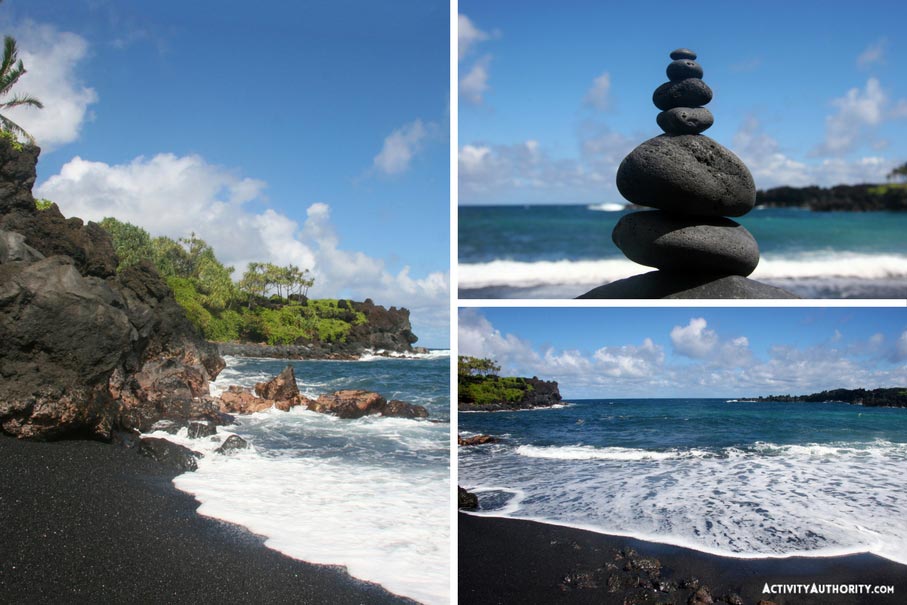
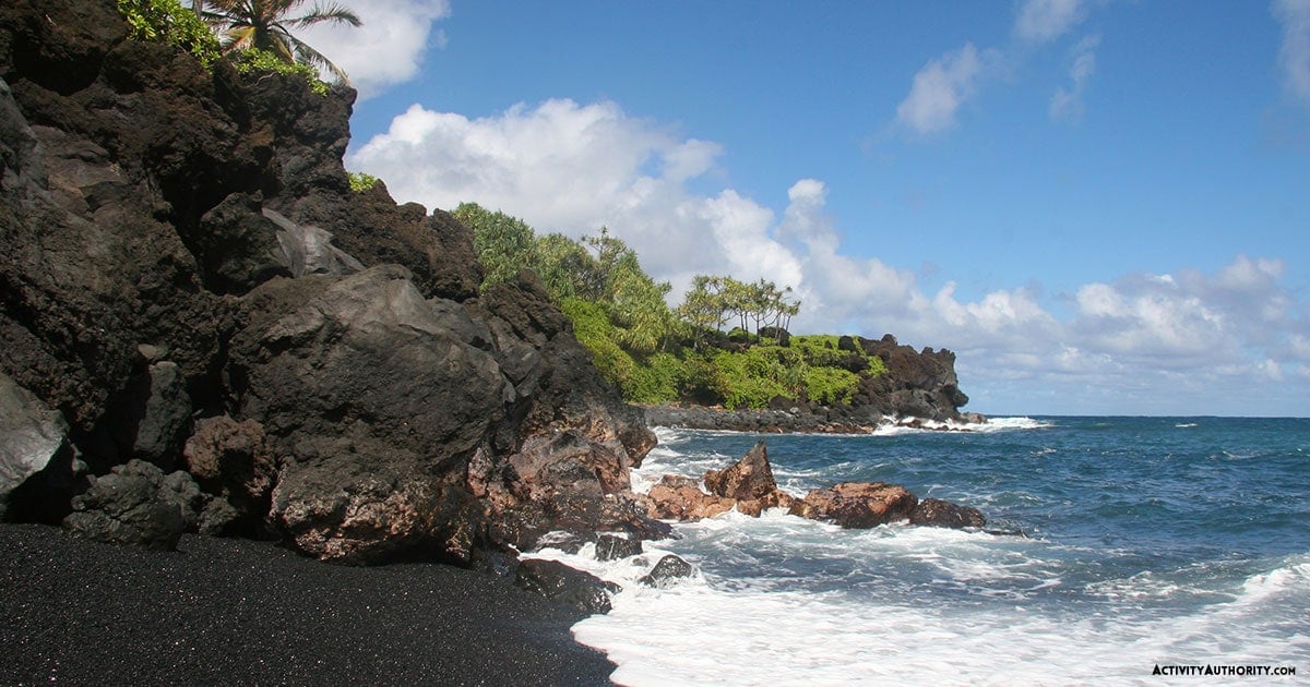
Every hike – no, every step – on Maui presents a feast of sensory pleasures, but Wai‘anapanapa might best represent the extent of the island’s natural wonders. Located on the way to Hana, this state park possesses more treasures than one can easily count. Chief among them? A mighty blowhole that scatters whitewash towards the sky, underwater grottos steeped in intrigue, ocean arches worthy of Instagramming, and a black sand beach – Paʻiloa – that sings with an otherworldly sound when waves peel over its pebbles. For the best experience here, check out Road to Hana Tours.
Hikes here are aplenty, but its loveliest might just be its coastal trail – a mesmerizing jaunt that parallels the shoreline. Along the way, you’ll spot a lava tube, ancient ruins, a hala forest, and a seabird colony; all the while, the Pacific – wilder on this windward side – churns in the distance. Not to be missed: tucked into the center of the park is a short hike to the park’s legendary caves, where, depending on the season, you may see the water run a haunting red. There are a number of guide companies that will take you on a Road to Hana hiking tour. You can see pricing and more info below:
Details, please:
- Located at Mile Marker 32 on the Road to Hana
- Approximately 2.75 miles; moderate
- Restrooms and picnic tables are available
To note:
As mentioned, the water here is rougher than Maui’s leeward beaches, rendering swimming hazardous during swells. The coastal trail continues all the way to Hana town (about 3 miles away) but requires crossing some daunting terrain. Beware of high surf, stay away from the blowhole, and watch your step – parts of the trail may be unstable.
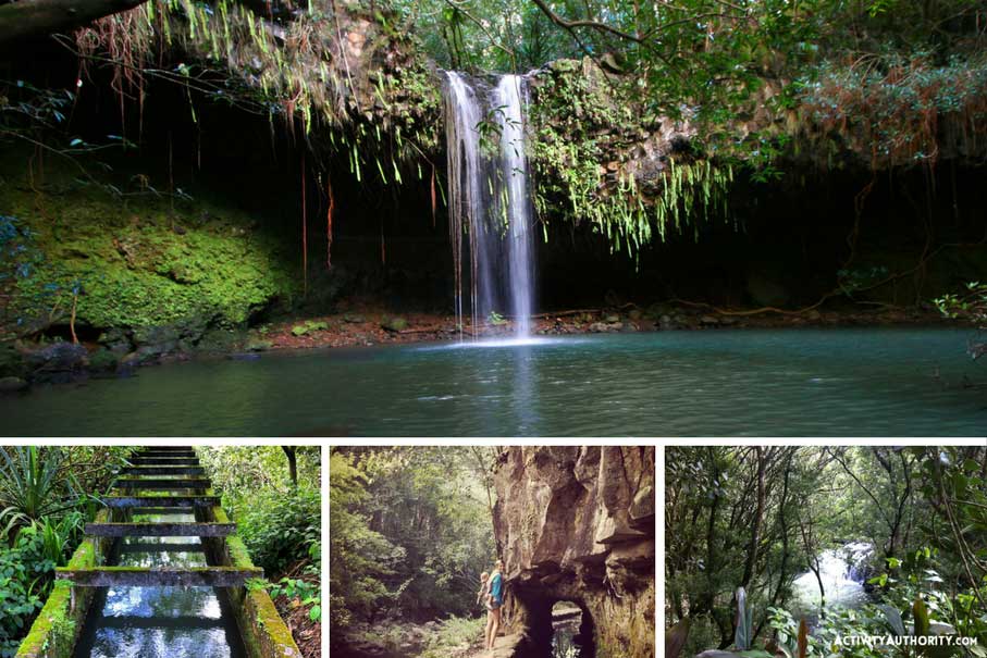
 2. Twin Falls
One of the many pleasures of Maui is that it boasts vastly varied landscapes (indeed, the island hosts 10 of the world’s 14 climate zones). Translation? That sunny morning by the pool could easily become a windswept ramble through a rainy jungle – should you just hop into your rental.
Twin Falls crystallizes the depth of the island’s diversity. Located on the Road to Hana in Haiku-Pauwela, this roadside attraction is often flush with visitors. And for good cause: hiking to its waterfalls is accessible to most and it’s only a short jaunt away from uber-cool Paia. What’s more, it takes guests through forests teeming with stunning foliage and rare treasures, all of which are fueled by the abundant rain that showers down on Hoʻolawa Valley.
But it’s the falls themselves that are the real showstoppers. “Caveman” is the most popular waterfall within this glorious string of cascades, and rightfully so, at that – the pretty falls are framed by tropical vines that dangle over ancient caves, while its freshwater pools catch rainbows on sun-drenched days. Best part yet? It’s a cliff jumper’s Shangri-La.
Details, please:
- Located at Mile Marker 2 on Hana Highway, 15-20 minutes from downtown Paia
- Approximate 1.3 miles (30-45 minutes) to Caveman; easy
- Parking available (though the lot is often packed)
- Equipped with Porta-potties
- Free and open to the public; donations welcome
- Refreshments – such as fresh fruit, coconut candy, cane juice, and smoothies – are available at Twin Falls’ Farm Stand (provided by Wailele Farm)
To note:
Like all hikes on Maui, safely hiking Twin Falls – and swimming in its waters – requires common sense and caution. (In 2016, a Chinese visitor died following an accident at the falls.) Refrain from venturing off the designated paths, know your limits when it comes to jumping and swimming, and don’t dive off ledges from which no one else is leaping. And keep in mind that residents live on the property – thus, as always, respect the ‘aina and heed the signs.
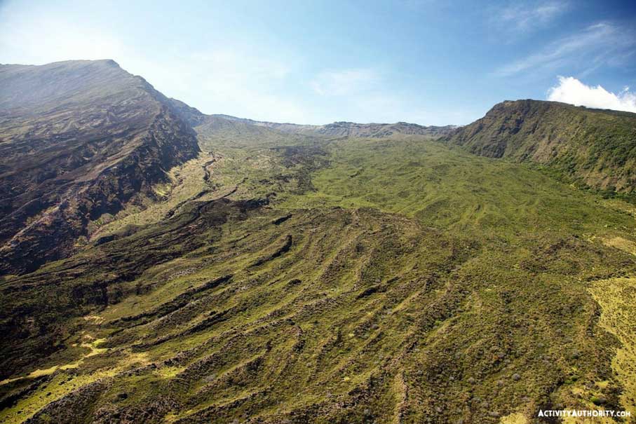
3. Polipoli Spring State Recreation Area
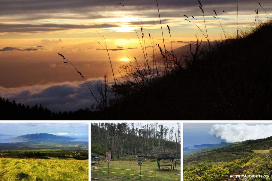
The effect of one of Hawaii’s first reforestation projects, Polipoli Spring State Recreation Area is a sight to behold: Ten splendid acres that sweep through Maui’s fog belt and give way to stunning views of its south-side beaches 6,400 feet below (thereby rendering it the highest-elevation hike on the island aside from Haleakala Crater).
Once inhabited by native flora – ‘ohiʻa lehua, mamane, koa, and more – the Kula enclave was resurrected from over-logging and cattle grazing in the 1920s, when cypresses, sugi, spruces, red alders, China Firs, redwoods, Mexican Weeping Pines, and eucalyptus were cultivated by the Conservation Corps. Four majestic trails grace the state park: the Plum Trail (which takes hikers past plum trees), the Haleakala Ridge Trail (which features cinder substrates from Haleakala’s fire), the Redwood Trail (which is precisely as it sounds), and its eponymous trail, which is marked by conifers that call the Pacific Northwest to mind. Taken together, and the maze of trails forms a loop that ends in a verdant hollow. The fauna here is magnetic – wild boars, axis deer, owls, Ringneck Pheasants, and Hawaiian honeycreepers – while the vistas include peeks of Lanaʻi and Kahoʻolawe in the misty distance.
Details, please:
- Located in the Kula and Kahikinui Forest Reserve off Waipoli Road in Kula. Access road traverses several switchbacks before it enters the forest. (4WD is recommended for the last stretch into the park.)
- Roughly 3.5 miles (to complete the loop); approximately 3 hours; moderate
- Picnic tables and restroom at the campsite
To note:
Bright attire is advised as hunting is legal in these parts. Keep to the trail and bring a jacket – given the elevation of the park, Polipoli confirms that everything is indeed cooler in Kula (nighttime temps dip below freezing). Use caution while hiking, as roots and forest floor may be slippery. And follow the path – in 2015, two hikers had to be rescued when they ventured off the trail and couldn’t find their way back.
4. Haleakala Crater
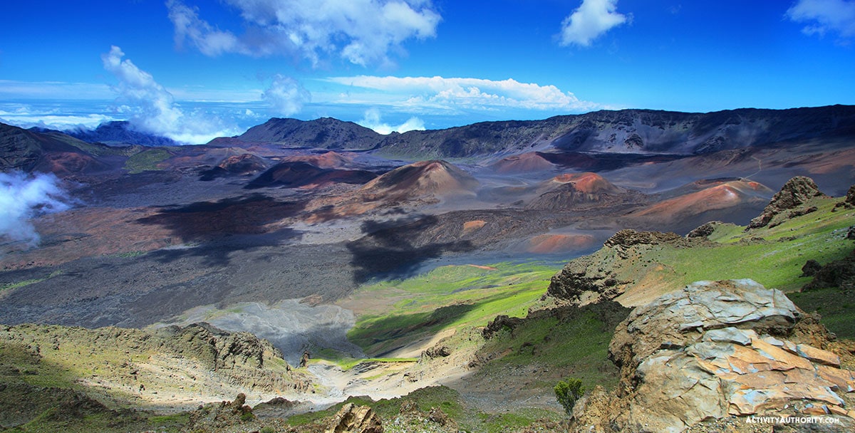
Haleakala, or “House of the Sun”, is home to one of the most unique hikes you might ever see. Towering 10,023 feet over the ocean, Haleakala is actually one of the tallest mountains in the world when you consider that the base of this mountain is almost 20,000 feet underwater. The “crater,” or the more scientifically correct “erosional depression” at the summit is one of the most sought-after destinations in Hawaii, and the hike down into the colorful basin is out of this world! As you descend down the Sliding Sands trail you will find one of the rarest plants in the world, the ʻahinahina or Silver Sword. With long silver leaves that glisten in the sun, you can start to see them all over the crater giving it a diamond-like sparkle as you hike. DO NOT GET TOO CLOSE. They are beautiful and rare and their root system is close to the surface and very fragile so even getting close to them can kill them. Just stay on the trail and you won’t have to worry. If you are lucky enough to see one bloom you will notice an epic display of a beautiful tower of purple flowers. They will only bloom once in their lifetime, which can be up to 55 years, so it’s an incredible experience to see one in full bloom.
Aside from some of the rarest species of plants and animals you might see on this hike, you will notice all different types of rock formations and terrain. Lava tubes, cinder cones, colorful rocks, and around 30 miles worth of hiking trails. This is a place that can really only be appreciated in person.
***Not only is this place beautiful but it also has a rich cultural history, if you would like to have a guide to answer questions and share some of the amazing histories of this place check this Haleakala Hiking Tour.
Details, please:
- Located at the top of Haleakala National Park; Keoneheʻeheʻ Trail (Sliding Sands) starts just below the summit at the visitor center.
- See the visitor center or visit the Haleakala National Park website for a trail map and more information
- Difficult hiking; much of the trail is loose, rocky, uneven terrain that gets very steep at times
- 3 Miles down to the first cinder cone is not too difficult but be prepared to take your time (3-4 hours)
- Going in Sliding Sands trail and out Switchback trail is around 11 miles (6-8 hours)
To note:
The main thing to know when hiking in Haleakala National park is that there is no water. You must bring plenty of water with you (1.5L or more is recommended for each person) as well as food, sunscreen, and first aid. The weather is another major factor, it can be incredibly windy making it difficult to balance, it can also rain and even snow, and on the other hand, it can also be desert-like heat. Bring layers of clothing, good hiking shoes, or boots, and ask the park rangers about expected weather to ensure you are properly prepared to hike.
 5. Kaupo Gap
Happen to be an avid hiker? You’re in luck – and not just because you’re in Hawaii.
The most intense of Haleakala’s hikes, this challenging trail begins at Paliku campground and descends to the Kaupo coastline – one of the remotest and most barren breadths of space on the island. Toothed lava, dry brush, clusters of kiawe trees, low native forests – as well as chance encounters with feral goats and Hawaii’s state bird, the Nene goose – compete with the attention demanded by the dazzling vistas. The ascent requires stamina and strength – the elevation gain here is almost 5,400 feet within 7 miles – but on clear days, you can relish views of the Big Island. Feeling indefatigable? Spend two days on the trail, with each day dedicated to either the ascent or descent (cabins are available at the crater, but must be booked well in advance).
Details, please:
- Located within Haleakala National Park; spans Kaupo Ranch
- Approximately 8.3 miles (5-7 hours); difficult
To note:
Given the duration and strenuousness of the hike, many trekkers choose to camp at Paliku campground to get an early start. Feral dogs have been spotted (and encountered) along the way, and dehydration is one of the most common risks and complaints. The descent can be troublesome on the knees – bring walking sticks to ensure smooth traveling.
6. Mahana Ridge Trail
Kapalua may be all tony resorts and glossy golf courses now, but its past is firmly rooted in Maui’s plantation era – a period that began on the island’s west side when Dr. Dwight Baldwin – a Connecticut-born Maui physician, missionary, and postmaster – was awarded 2,675 acres of land for farming and grazing. By 1902, that tract of land had grown to 24,000 acres, much of it filled with pineapple, coffee – and the Norfolk pines that adorn the region today.
Mahana Ridge Trail offers hikers a glimpse into this bucolic past. As the longest continuous trail in Kapalua, the trek begins near D.T. Fleming Beach Park and climbs roughly six miles to the Maunalei Arboretum – a plot of land, established 80 years ago, that’s filled with Suriname cherries, coffee, shoe button Ardisia, and kauri trees, maile shrubs, and ‘amu‘a ferns. From its path, you can gaze down at the rippling green valleys of Honolua. Prefer not to break a sweat? Take a complimentary shuttle to the arboretum and stroll down to the coastline: Swimming at D.T. Fleming’s is downright stellar.
***The Kapalua ziplines are not far from here if you want to see these views from a different perspective or take the thrill to a new level.
Details, please:
- Located in Kapalua, about 20 minutes west of Lahaina
- Approximately 6 miles (4 hours); moderate
To note:
Hikers have been helicoptered off this trail due to dehydration. In other words, bring plenty of water – and sunscreen: Despite the lushness and shade in some parts, the trail is also prone to sunshine.
For a tour of this area check out Helewai Eco Tours.
7. Pipiwai Trail
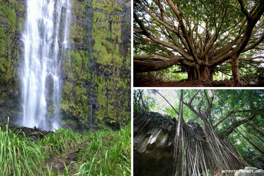
Inarguably one of the most renowned trails in Hawaii, Pipiwai Trail is a rare gem in a field of already-stunning jewels: a four-mile trek on the island’s wet windward side that allows visitors to saunter through copses of bamboo, past a banyan so grand it’ll take your breath away, and along ridges that peer into luxuriant, tropical gulches. And though shady, serene, and pleasant as they come, the walk is not all for naught: Along the way, you’ll be treated to views of the 185-foot Makahiku Falls before reaching the island’s largest cascade, Waimoku Falls – a 400’ waterfall that reasserts Maui’s grandeur.
Details, please:
- Located at Kipahulu Visitor Center, around Mile Marker 42 on Hana Highway
- 4 miles roundtrip (roughly 2-3 hours); 600’ elevation; easy to moderate
- Parking is available at Haleakala National Park/‘Oheo Gulch; $30/car (good for 3 days and can be used at Haleakala Summit)
To note:
Though much of Pipiwai Trail is comprised of a wooden boardwalk, the trek remains susceptible to East Maui’s unpredictable weather, including flash floods and rockfalls. Pay attention to the weather, stick to the trail, and refrain from cliff/bridge jumping.
8. ‘Iao Valley
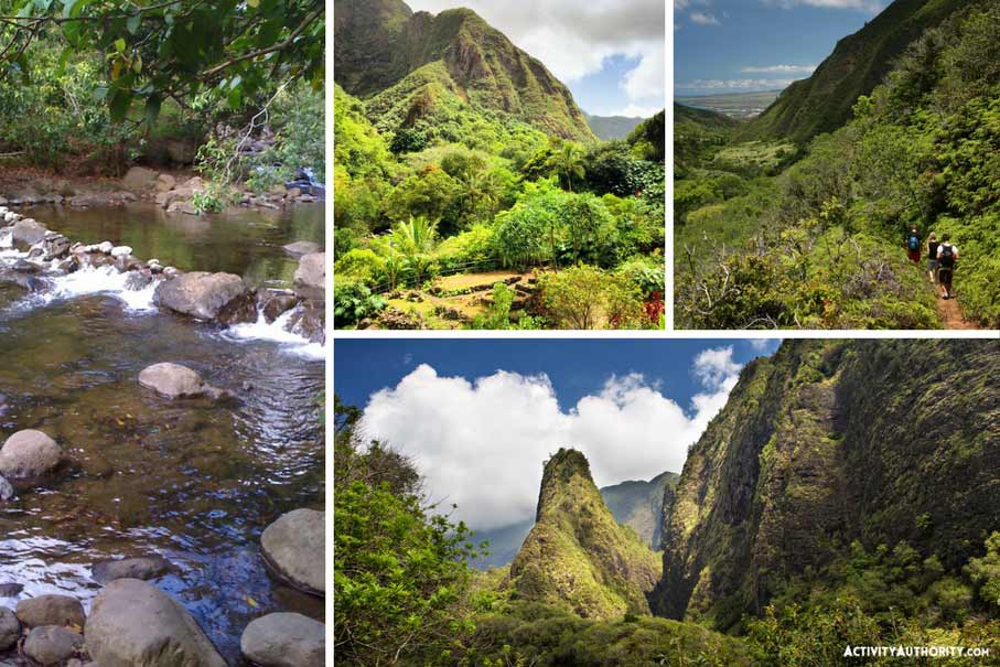
Travel through Maui’s central plains, and there’s hardly a chance you’ll miss the sight of ʻIao Needle – the erosional vestige of West Maui’s last eruption 320,000 years ago. Emerald-green and surreally shaped, the needle, Kuka’emoku, rises 1200 from the valley floor. Its surrounding valley is largely noted as the site of the Battle of Kepaniwai – the 1790 invasion of King Kamehameha that resulted in the unification of the Hawaiian Islands. The sacredness of the region continues to be felt today in its often-surging stream and botanical wonderland, where endemic and non-native species grow in a cacophony of green. ‘Iao’s short hike is accessible to most and presents beguiling views of deep vales, titillating ridges, and the island’s coastline – so beautiful, in fact, that Mark Twain dubbed this National Natural Landmark the “Yosemite of the Pacific.”
Details, please:
- Located approximately 10 minutes west of downtown Wailuku
- $10 Parking Fee For Non-residents
- 0.6 miles; easy
To note:
‘Iao Valley has been closed since September 2016 (after facing significant flooding from a major storm), but its pavilions and lower restroom are now open. While these parts of the park are currently open from 7 am to 7 pm, it’s best to arrive early before the clouds roll in.
9. Kahakapao Loop Trail/Makawao Forest Reserve
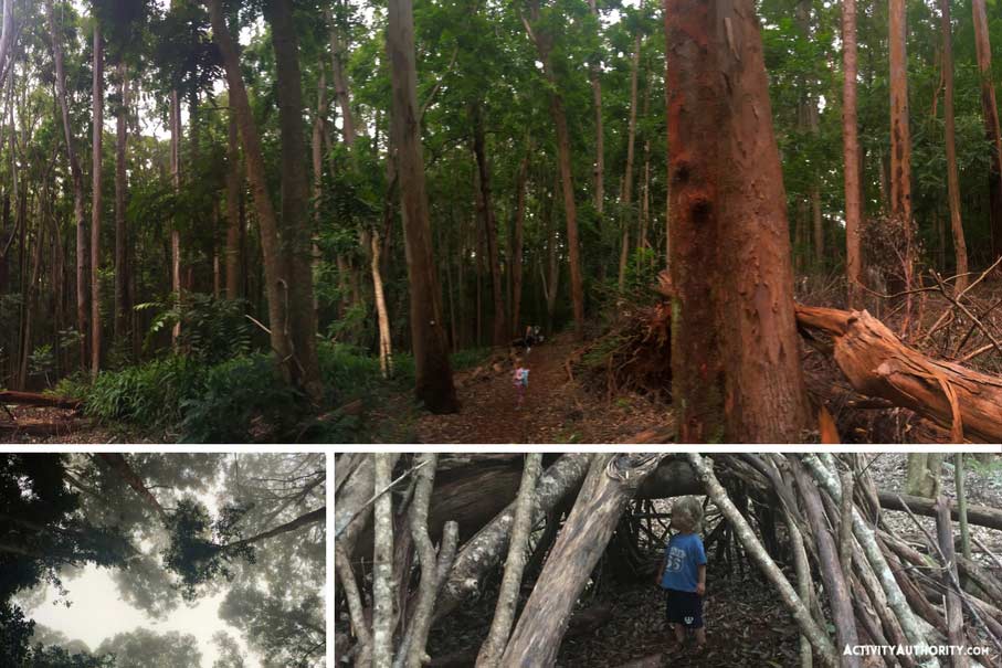
Lofty stalks of eucalyptus and Cook pines line the trail of this bike lover’s paradise, where families and thrill-seekers can be found in equal numbers. The chief trail within this 2,093-acre park is the Kahakapao Loop Trail, which runs parallel to a gorge and through a fertile forest, much of it planted during the turn of the century. Amid the sound of birdsong, you’ll come across white ginger, ti, and tropical ash, as well as ʻleʻie vines, ohia, koa, and halapepe trees. Located 3,000 feet above sea level, this lovely, calming trail is Muir territory – all mist, mystery, and quiet invigoration.
Details, please:
- Located four miles from downtown Makawao
- 5.75-mile loop (for Kahakapao Trail); easy to moderate
- Picnic tables provided on the east and west ends
To note:
Dress in layers for the lower temps. Also, exercise caution along the path: Makawao is one of the rainiest regions on the island, and the trail tends to be more slick than dry. And keep an eye out for bikers: This is one of only two state-run biking paths on Maui.
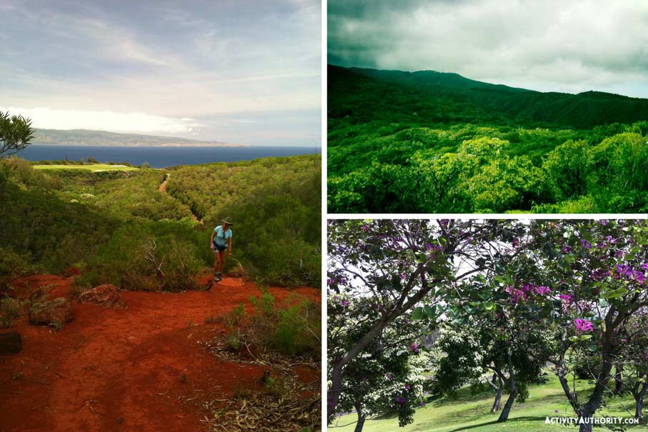
10. Hoapili Trail
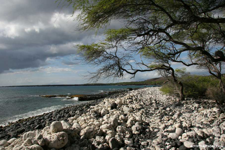
Once known as Alaloa Kihapiilani – in deference to the ancient chief who oversaw its completion – King’s Highway was the first footpath to circumnavigate the entire island. Contemporary roadways, modern expansion, and the plantation industry have since rendered this sacred path nearly obsolete; whole patches today are rarely seen by kamaʻaina, let alone visitors.
You can be one of the few (and step back into the past while you’re at it) along the Hoapili Trail on Maui’s sun-splashed southern end. Beginning at La Perouse Bay in Makena, the trail may be hot, barren, and grueling, but the quiet it affords – and the sights you’ll come upon – will stay with you for a lifetime, from an isolated beach that provides close-up views of Molokini Crater’s backside to stark, enchanting fields of barbed lava. You’ll also pass ancient ruins of Hawaiian civilizations, temples, and shrines, tidepools gleaming with exquisite marvels, and kiawe trees that have weathered more than one gale. Meanwhile, Haleakala – which created the region during its last eruption in 1790 – looms above it all like a god. Skirt towards the stately mountain when the trail forks off towards the lighthouse (Cape Hanamanioa) and then make your way to Kanaio Beach, a coral-strewn cove with nary a footprint in the sand. The other side of Maui, indeed – and perhaps its most gorgeous.
Details, please:
- Located at La Perouse Bay at the end of Makena Alanui, 3.1 miles past Makena State Park (Big Beach)
- Roughly 5.5 miles roundtrip (4-6 hours); moderate
BONUS!
11. Waihe’e Ridge Trail
Haleakala National Park may get most of the love – as in 1.3 million visitors per year – but the West Maui Mountains, though more modest in size, are just as spectacular. Known as Mauna Kahalawai, the shield volcano’s erosion has transformed the range into one of the lushest, most dramatic regions on the island: a 52,000-acre expanse where serrated mountains spike the sky and green rolls out in every direction.
Waiheʻe Ridge Trail presents one of the most striking views of this splendor. Located past Wailuku on the way to Kahakuloa Head, the clear-cut (though muddy) trail gets the heart pumping on its first ascent before meandering through forests of guava, kukui, and ohia, and across ridges that peer down at verdant, undulating valleys. Ending at 2,563 feet (complete with picnic tables for tired legs), the vistas stretch across gorges to the rugged central coastline. Bonus points: 3/4 of a mile in you’ll catch peekaboo glimpses of Makamaka’ole Falls.
Details, please:
- Located across the way from Camp Maluhia, about 20 minutes from downtown Wailuku
- Approximately 5 miles roundtrip (2 hours); moderate with steep sections
- Hiking/running shoes recommended
To note:
A number of accidents have occurred on Waihe’e Ridge Trail. Exercise extreme caution alongside ridges, keep to the trail, wear shoes with good traction, and anticipate muddy/slippery sections. And start early: The trail tends to get cloaked in clouds by mid-morning.
To note:
To avoid dehydration, overheating, and excessive sun exposure, plan your trek for the early morning or afternoon. Wear sturdy shoes suitable for rugged terrain, as much of the hike goes over sharp a’a (lava).
Prefer to go on a guided tour of one of Maui’s waterfalls – or within its famed crater? Book a trek with Maui Waterfall and Rainforest Hike and let a team of knowledgeable guides take you and your crew to the island’s best spots.
Comment encourager: Did we miss your favorite Maui hike? Do tell in the comments below!


I think the best hiking is the kind where you’re also helping the environment and restoring previous areas.
I spent three summers on Maui when I was in college learning archaeology.
My class, a group of about 13 students and our professor were excavating a Heiau on Mike Love of the Beach Boys’ property. We wold drive there every morning, hike then clear brush and dig all day collecting artifacts that would help determine what type of activities had happened there. During lunch we would take a break and eat and swim at an amazing fresh water pool that ran out of the rain forest and down to the ocean at the beach, it was breathtaking.
One day, a monk seal lumbered up over the rocks at the beach and decided to come check us out. Since they are endangered, we couldn’t interact with him. He had us pinned up on the rocks around the pool while he swam about and checking us out. He was very curious. After about 10 minutes he clambered out of the pool and actually worked his way over to my beach towel and proceeded to lay on it like a sunbather sticking his nose in my work boots I had left with the towel. He got a boot stuck on his snout and threw his head around for a bit before it dropped off. He then laid there for about 20 minutes sunning himself before finally leaving us behind back to the sea. It was one of the most incredible encounters I’ve had with a wild animal.